A visit to Paronella Park

park15I’d driven the road from Townsville to Cairns in 2013 but at that time I’d not heard of Paronella Park. I headed up that way again in 2017 and in the intervening years I’d heard multiple times Paronella Park was worth a visit and had won many tourism awards. So I added it to my itinerary between Cardwell and Innisfail. The park is not new, it has been open since 1935. As I drove north I saw many billboards advertising its charms and wondered why I didn’t notice it before. Was it simply clever marketing in the last few years that had raised its profile?

park1

Paronella Park is an extraordinary place with an extraordinary story. Situated at Mena Creek it is a 15km detour from the Bruce Highway, 200km south of Cairns.  I parked on the south side of the creek at a lookout admiring Mena Creek Falls. It was the dry season so not at its most spectacular but sitting pretty right next door was Paronella Park in all its glory.

park2

The Park is approached by a swing bridge which looks down on the creek below and part of the ornate park. The park was a pre-war dream of Spanish immigrant José Paronella who wanted to build a Castilian castle in the Australian tropics. Paronella was born in February 1887 in La Vall de Santa Creu, a small village in Catalonia. On five hectares of virgin scrub beside Mena Falls he built a park with a castle, picnic area by the falls, tennis courts, bridges, a tunnel, and covered it with 7500 tropical plants and trees that is now a lush rainforest.

park4

José Paronella’s father tended olives for local farmers and his grandmother’s tales of “romantic Spanish castles” and the “nobleza” profoundly influenced José’s dreams. He moved from Catalonia to Cairns in 1913. For 11 years he worked hard, cutting sugar cane then purchasing, improving, and reselling cane farms. By 1921 he was an Australian citizen and a wealthy man. Paronella received an extortion letter from The Black Hand demanding £500. The Black Hand was established in Sydney and Melbourne, and was making inroads into the Italian communities in Innisfail with many murders, bombings, and blackmails. Paronella was susceptible to extortion as he had been involved in tax evasion. In 1924 he returned to Spain under a false name intending to marry Matilda Soler, his betrothed before coming to Australia. But Matilda had found another man so he married Matilda’s younger sister Margarita instead. He took Margarita back to Australia where the couple worked hard together to build their fortune. They also had two children Teresa and Joe (Jr).

park16José first saw his park in 1914 but it wasn’t until 1929 he was in a position to buy it which he did for £120. Immediately he got to work building his pleasure gardens and reception centre for public enjoyment. Paronella was strongly influenced by the Moorish architecture and gardens of Spain, and the design of villa gardens visited during his European honeymoon. He also admired the work of Antonio Gaudi, and created garden elements inspired by the Alcazar Garden in Seville and the Botanic Gardens in Madrid.

park12

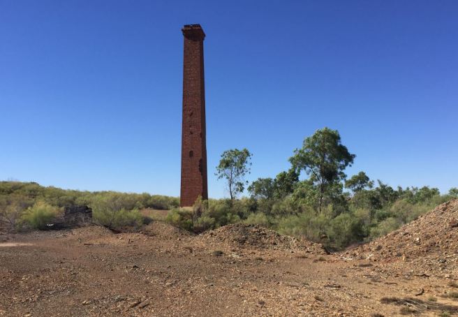
The earliest structure, the Grand Staircase, was built to carry river sand to make the concrete. The steep structure has reminders of past floods. The two brown tiles half way up represent the 1996 flood level (lower) and 1967 and 1994 (upper). Near the top is a third tile representing the huge height of the 1946 flood.

park13

After building a house for themselves, the Paronellas started on the castle and accompanying lookout towers and pillars. Apart from the stone house, all structures were constructed of poured, reinforced concrete from old railway track. The concrete was covered with a clay and cement plaster with fingerprints a reminder it was all done by hand.

park5

It took six years of building and the buzz grew at the scale of the project. In 1933 the Brisbane Sunday Mail reported what the “pleasant-faced Spaniard” was up to in the Deep North. The paper was impressed but struggled to avoid racist overtones. “Joe Paronella. An amazing fellow of 47 and with none of the swagger the world has pinned to his race.” When asked him why he put so much effort into it, he replied: “I wish to do something. I make my money in (the) sugar industry and in selling my farm. I travel and see the world twice. Never do I see any place as beautiful as Queensland.”

park6

Paronella did much of the work himself. He employed a canecutter who had worked as a carpenter in Malta and the canecutter’s nephew to work on the project full-time. He used many unemployed men who moved to Innisfail and exchanged food and shelter for labour. In 1935, the Park was officially opened. Queensland governor Leslie Wilson was at a conference in Innisfail and visited the new park. Wilson told journalists “Paronella has created a place of beauty which will be a great attraction to visitors in the future. His buildings are of unique design. The Park is a credit to North Queensland. It is absolutely remarkable to see what one enterprising man can do.” Access to Mena Creek from Innisfail had improved and the park was immediately popular. It boomed during the war years as thousands of American servicemen arrived with money to spend.

park8

The theatre showed movies every Saturday night. When they removed the canvas chairs from the hall it was transformed into a venue for dances and parties. The highlight of the ballroom was a myriad reflector, a great ball covered with 1270 tiny mirrors, suspended from the ceiling. Its pink and blue spotlights shone on the reflector from the corners of the hall and when rotated slowly, it produced a coloured snowflake effect. Upstairs was the Paronella Museum housing coins, pistols, dolls and samples of North Queensland timbers. A disastrous fire swept through the Park and destroyed the hall and cafe in 1979. The Park was closed for years, but was slowly revived despite further cyclone and flood damage.

park7

The tunnel of love was built in 1932-1933. The reinforced concrete structure provided a short cut to the fernery. It was closed in 1993 for safety reasons. The closure has allowed a colony of little bent-wing bats to grow from 40 to 500.

park10

Paronella planted these majestic rows of Queensland kauri pines (Agathis robusta) in 1933. They can live for a thousand years. He planted 7000 trees and the park was threaded by pathways, bridges and avenues. He also built a shaded orchid and fern house for Margarita to tend exotic plants.

park11

An astonishing feature is a hydroelectric power station, the first in North Queensland. Installed in 1933 it worked using gravity to Paronella’s own design. Water falls nine metres into the turbines coupled with a DC generator.  A belt-driven governor controlled the speed and changed the angle of water flow to maintain constant rotation speed. Paronella used the station to power the park though he had to change it to AC after the 1946 floods. Cyclone Larry destroyed it in 2006 but the current owners restored it with the help of a German company specialising in old hydro systems. Running again since 2010, it powers the park and also supplies the grid.

park14

Two years after the significant damage of the 1946 floods, José died of cancer, leaving Margarita, Teresa, and Joe, to carry on. Teresa married and moved to Brisbane while Joe married Val in 1952, and they had two sons, Joe (José) and Kerry. Floods, renovations and maintenance kept them busy. After Margarita died in 1967 and son Joe in 1972, Val found it too hard and sold up in 1977. The park was closed after the 1979 fire. Mark and Judy Evans purchased it in 1993 with a plan to restore the Park. They see it as a work of art, and work on maintaining and preserving, rather than rebuilding.

A trip to the abandoned Mount Elliott mine and Selwyn ghost town

I’m fascinated with the old abandoned mines and ghost towns of North West Queensland such as Mary Kathleen and Mt Frosty. Many, like Kuridala, briefly flowered in the early 20th century with small vibrant towns attached only to disappear just as suddenly when the copper boom ended in the early 1920s. I’d taken the rough road to Kuridala before but did not realise another equally interesting old copper mine lay a further 25km down that road. Mount Elliott and Kuridala led parallel existences and were fierce rivals but both are now deserted. As at Kuridala I was apprehensive I’d find it given the lack of signposts in an isolated area, but just like Kuridala I found it thanks to a prominent chimney.

elliot1

The copper field at Hampden (Kuridala) was discovered in the late 1890s and the investment of Melbourne capital prompted the discovery of other fields near Cloncurry. In 1899 hermit gold fossicker James Elliott blasted trenches and found rich red oxide of copper on the conical hill that became Mount Elliott.

elliot2

As Geoffrey Blainey says in Mines in the Spinifex, Elliott was an old man with a past masked in tragedy. He was sentenced to death for robbing and murdering a Chinese man before the real murderer confessed on his deathbed. Now his luck finally turned. He sold his interest to Fort Constantine pastoralist James Morphett but the Federation drought forced Morphett to sell to mining promoter John Moffat. Moffat financed the exploration of the ore body which by 1907 had 45,000 tonnes of rich copper ore ready to be mined.

elliot3

1907 was also the year the mine was floated on the London market and the year James Elliott died. Novelist Randolph Bedford said Elliott claimed to have found an even larger lode – at Mount Isa. Whether true or not, the Mount Isa lode was not discovered for another 16 years.

elliot4

The 1907 London price for copper was £87 a ton, the highest price for 30 years, and the Cloncurry fields pulsed with life. The railway extended west from Richmond to Cloncurry and there were calls to extend it to the Hampden and Mount Elliott copper fields.  A new town called Selwyn sprung up to service Mt Elliott. Horse teams hauled boilers and mine machinery as well as stores and corrugated iron for buildings.

elliot5

General manager of the mine W.H. Corbauld altered the furnace and erected three converter shells before the first train arrived in August 1910. Blainey said the smelting works with their iron roofs were an impressive sight, “flashing in the sun, three tracks of railway running through the spinifex, and the stacks of firewood piled high for the boilers.” In four months the furnace extracted £125,000 of copper and gold. The copper was the richest in the Commonwealth and the gold was richer than many Victorian fields.

elliot6

Mount Elliott’s wealth was in the upper zone with enough ore for five years of mining. Beyond that was lower grade sulphide ore and Corbauld needed a central treatment plant to make it pay. Mt Elliott and Hampden could not agree on merger terms and remained fiercely competitive gobbling up nearby smaller mines.

elliot7

In 1912 Mount Elliott bought up the Hampden Consols mine on their rival’s boundary with its large deposit of sulphur, iron and copper which made it an ideal smelting mixture. Every week trains loaded with Consols ore under the nose of the Hampden plant and despatched it 30km south to Mt Elliott. In 1913 Consols mine caught fire. The loss hit the company hard when its rich reserve was rapidly depleting. After a strike against contract rates, Mt Elliott closed for seven weeks putting 900 miners out of work.

elliot8

Its London-based owners bought up nearby Mount Oxide, Great Australia, Dobbyn and Crusader mines. The First World War sent the copper price soaring so the poorer ore of Mt Elliott became profitable. The company deepened the mine, improved the smelter and bought a fire refinery south of Townsville. In 1917 they doubled the length of the furnace to smelt a larger tonnage of low grade ore.

elliot10

Living costs were high in Selwyn, amenities were few and the possibility of strikes were always high as was summer flash flooding. By 1918 Hampden Kuridala had eclipsed it in prosperity yet Mt Elliott continue to make a profit. Corbauld laid a post-war master plan for it to become a world class “copper camp”. But rapidly falling copper prices put paid to those plans. Mt Elliott re-opened in 1919 after a Christmas strike but within two months were forced to dismiss 650 workers. They left for the coast never to return. The smelters never re-opened.

elliot9

“The blast of the mine whistle was not heard in the valley again,” Blainey wrote in 1960. “All that now remains of Mount Elliott are ransacked smelters, a railway siding, a post office in a creaking tin shed and one house.” By 1961 the railway closed despite graziers’ objections there were no good roads in the area. Now even the post office and shed are gone and nothing remains of Selwyn except a cemetery. The roads remain poor. However Mount Elliott remains a working mine and the old mine was added to the Queensland Heritage Register in 2011 for its “potential to provide important information on aspects of Queensland’s history particularly early copper smelter practices and technologies, the full range of activities peripheral to those base operations and, importantly, the people who lived and worked in this complex historic mining landscape”.

Karlu Karlu: To Tennant Creek and the Devils Marbles

The last time I went to the Devils Marbles was in 2002 on a driving trip from Brisbane to Alice Springs. We didn’t stay long but the amazing shapes and rock formations remained in my memory. Living in Mount Isa they are “just” seven hours away so feel like they are in my back yard. In January I finally had a spare weekend to revisit the place. I left late Friday so only made two hours to Camooweal on the Queensland side of the border. As this mural shows, Camooweal was founded as a droving outpost between the Territory and southern states. Though trucks have long replaced walking cattle through “the long paddock”, Camooweal boasts an important Drovers Museum open each winter and a drover’s festival in August.

IMG_4875 (2)

I stayed in a donga at the back of the roadhouse, had a quick beer at the Camooweal Post Office Hotel (I would be back the following weekend for the famous Australia Day lawnmower races) and watched the sun set in the direction I was heading in the morning – west to the Territory.

IMG_4744

I was up early in the morning and quickly drove the 12km to the border. The Welcome to the Territory signpost is a selfie stop for anyone visiting Camooweal but this was my first time driving past it in two years in North West Queensland.

tc1

After the border was the pleasing sight of the NT 130kph speed limit (up from 110kph in western Queensland). With Tennant Creek 470km away and nothing much in between, it shaves valuable time off the journey, doable in under four hours.

tc2

About 50km on is Avon Downs. Avon is home to a large pastoral station owned by AA Co and a police station which does important work along the lonely border especially against the sly grog trade from Isa into the Territory Aboriginal communities.

tc3

After a lot of nothingness along the Barkly Tableland, I arrive at the Barkly Roadhouse, 260km from Queensland. Two hours into the journey is a perfect time for a fuel refill, toilet break and importantly a decent cup of coffee. We stayed the night here on the return leg of the 2002 trip and I recall the largest steak I’ve ever consumed in my life. Today, it’s just the cup of joe and on to Tennant.

tc4

I detoured a few kilometres north of Tennant Creek to check out the Telegraph Station. The creek here was a reliable source of water for Aboriginal people for 40,000 years and nine Aboriginal groups call the area home, including the Warumungu, Warlpiri, Kaytetye and Alyawarra people. In 1860 explorer John McDouall Stuart came through on his unsuccessful first attempt to cross the continent south to north. He named a creek after expedition financier John Tennant. Work on the overland telegraph line began in 1870 and Tennant Creek was one of 11 repeater stations between Port Augusta and Darwin as Australia opened up instant communication with the world. Completed in 1872 the station hosted a post office and became an important staging point for travellers and rations depot for dispossessed Aboriginal people.

tc5

The town of Tennant Creek was not established until well into the 20th century.  The township was stiuated 12km south of the creek because the Telegraph station had an 11km reserve. Gold was discovered in the 1930s starting Australia’s last great Gold Rush. The town quickly grew to 600. Today it remains an important gold mining town with a population of 3000 – about half Indigenous.

IMG_4765

Battery Hill goldmine overlooks the town and hosts of one of the last two operating ten-head stamp batteries and a government-owned ore crushing machine. These days it’s all for tourism purposes with underground tours and museums which were closed on the Saturday morning I visited though the great views over town were still open.

tc16

Having found a motel, I drove 110km south down the Stuart Highway to Karlu Karlu, the Devils Marbles (the apostrophe is omitted). The rocks in a conservation park are spread over a wide area. I parked in the northern car park and set off on a 5km trek.

tc6

Karlu Karlu is a living cultural landscape, a sacred site, and traditional country for Warumungu, Kaytetye, Alyawarra and Warlpiri peoples. Since 2009 it has been jointly managed by traditional owners and NT Parks and Wildlife. Among the many walks is the Nurrku Walk named for the small mallee eucalypt called the snappy gum. This brittle tree often grows on gravelly rises among the spinifex. Aboriginal people used the Nurrku for firewoods, medicine and bush foods including the “sugarbag” honey left by native bees.

tc7

The boulders’ distinctive shapes are due to erosion of remnants of a solid mass of granite which lies below. In John Lewis’s 1872 account of the building of the telegraph line, they passed through “extraordinary shaped stones” in the Davenport Ranges. “The country was of granite formation and many stones were round like marbles,” Lewis wrote. “In fact they were called Devils Marbles”.

tc8

The process of creating these rocks was the earth’s work not the devil’s. Around 1700 million years ago, molten magma squeezed through sandstone rocks and cooled into granite. They shrunk as they cooled and earth pressures caused right-angled patterns of cracks called joints to form. As the rocks above eroded, the granite emerged to the surface. Groundwater filtered along the joints and reacted with minerals in the humid climate to form clays. This weathering was most noticeable at the corner of the blocks which had more exposed surfaces.

tc11

Eventually the overlying rocks withered exposing the granite. When the weathered bits washed away, it left boulders perched in precarious positions across the landscape.

tc10

Though the boulders appear solid, many are fractured by their joints. Rainwater penetrates into the stone reacting with minerals decomposing them to clay. Critical cracks form and the weight of the two halves causes the boulder to fall apart.

tc12

The area is a sacred site with many parts (not shown) forbidden to photograph. Karlu Karlu is an important dreaming site, and most dreaming stories can only be known by appropriate Aboriginal people. There is a practical reason for husbanding this information. During rains water collects in rockholes providing an important water source in a difficult environment.

tc13

Karlu Karlu is the Aboriginal term for both the rock features and the surrounding area. It translates as round boulders and refers to the large boulders found mainly in the western side of the reserve. The rust colour from the iron oxides makes the rocks look like giant sweet potatoes.

IMG_4836

After a delightful couple of hours among the boulders, I was thirsty and headed five minutes drive south to Wauchope. There’s not much at Wauchope except for the fine building that hosts the Devils Marbles Hotel.

tc14

Wauchope was established in 1917 to service wolfram (tungsten) mining operations. Wolfram was used in munitions manufacture and mining continued to 1941 when the tungsten price plummeted. Miners extracted 1000 tonnes of concentrate from 10,000 tonnes of quartz. The pub opened in 1938.

tc15

That evening I returned to Tennant Creek and went for a run along the 5km bicycle path north of town to Tingkkarli/Lake Mary Ann. This human-made lake provides a water supply for the town and is a cool oasis, even for perspiring runners.

tc17

On Sunday it was the long and lonely Barkly Hwy drive back to Mount Isa. The need for a good road between Northern Territory and Queensland was long recognised but it took the danger of impending world war to make it happen. Authorities proposed a supply link between the Mount Isa railhead and the Alice Springs-Darwin North-South Road in October 1940 during the formation of the North-South Road. Initially a road was planned from Newcastle Waters to Camooweal but the project was shelved until March 1941 when the Army gained approval to construct a road by the most direct route from Camooweal to Tennant Creek. This road was named the Barkly Highway in 1944 for a Victorian governor. The North-South Road was named the Stuart Highway for the explorer.

24 hours in Singapore

I didn’t much time to spare at the end of my Christmas trip to Ireland but I was determined break up the long London-Brisbane leg. Singapore is hardly the most exotic Asian location around but it is strategically placed and convenient and with just 24 hours to kill is easy to get into and around. Though ruled by the same political party since independence in 1965 Singapore ranks fifth on the UN Human Development Index and the third highest GDP per capita and also ranks highly in education, healthcare, life expectancy, quality of life, personal safety and housing.

sing2

I took the metro from Changi Airport to Bugis station where my hotel was a short walk away. I then went to Marina Bay towards the colonial heart of the city. The National Gallery of Singapore is housed in the adjoining City Hall and old Supreme Court Building. The latter reminds me of the Four Courts in Dublin with its blue-green dome, Corinthian columns and classical design but this was only built just before the Second World War. It finished work as a courthouse in 2005 and re-opened as the national gallery in 2015.

sing6

Across the road is the Victoria Theatre and Victoria Concert Hall.  The hall was built in 1905 and contains a 614-seat theatre and a 673-seat concert hall. In 2010, the heritage-listed building underwent a four-year refurbishment to restore its neo-classical facade while getting new facilities inside.

sing4

The Singapore River meets Marina Bay in the heart of downtown. Ferry boats ply tourists up and down the river overlooked by skyscrapers and the Marina Bay Sands resort. The resort includes a 2561-room hotel, a 120,000 sq m convention centre, a 74,000 sq m mall, a museum, two large theatres,  two floating Crystal Pavilions, a skating rink, and the world’s largest atrium casino. Sitting on top of the complex is the world’s largest public cantilevered platform holding a 340m long Skypark.

sing5

Along the side of the river is Boat Quay and bars and restaurants line the pedestrianised streets. It gets lively on a Friday night with expats enjoying the British-style pubs while couples seek a river-side table to enjoy dinner and the city nightlights. Boat Quay was the busiest part of the old Port of Singapore, handling three-quarters of all shipping business during the 1860s. The bend of the river at Boat Quay resembles the belly of a carp, which according to Chinese belief is where wealth and prosperity lay. For that reason they built many shophouses crowded into the area.

sing7

The river empties out into Marina Bay which links to the Singapore Strait and the sea-lanes of the world. The port of Singapore is the world’s busiest port in shipping tonnage handled, with 1.15 billion gross tons handled in 2005. In cargo tonnage, Singapore is behind Shanghai with 423 million freight tons handled.sing8

The tourist highlight of Marina Bay is the Merlion. The merlion is a mythical creature with a lion’s head and the body of a fish and serves as a mascot and national personification of Singapore.  The fish body (“mer” as in sea) represents Singapore’s origin as a fishing village when it was called Temasek, which means “sea town” in Javanese. The lion head represents Singapore’s name—Singapura—meaning “lion city”.  However the symbol is relatively new, designed as a logo for the Singapore Tourism Board in 1964 and has been its trademarked symbol since 1966. The statue was built on the estuary in 1972 but moved to a more central location in 2002 when a new bridge blocked its view.

sing9

Fort Canning Hill overlooks downtown and the area was once the centre of ancient Singapura in the 14th century. When Sir Thomas Stamford Raffles was appointed Lieutenant Governor of the British colony at Bencoolen in Sumatra in 1818 he wanted to end Dutch domination of the Malacca Strait. Raffles established a new port on the island of Singapore signing the treaty of Singapore with the Sultan of Jahore. The hill was the site of the first British Residence and also a botanical garden and a fort was built in 1861 named for Charles John Canning, first Viceroy of India. The official British surrender to the Japanese was signed here on 15 February 1942.

sing11

The Arts House at Old Parliament House plays host to art exhibitions and concerts. Built in 1827, the Old Parliament House is the oldest government building and possibly the oldest surviving building in Singapore. It housed the Parliament of Singapore from the nation state’s beginning in 1965 to 1999, when it moved next door to accommodate a larger number of MPs. The Arts House opened in 2004.