Once a month I try to attend a new parkrun venue. The original idea for March was a train to the Sunshine Coast and cycle to Caloundra for an ocean swim before doing the run on Saturday morning. However early in the week, my bike played up and the bottom bracket broke, a part my local shop said would take a fortnight to get. Cooling my heels I decided on plan B, a bus to Toowoomba for a run in the Garden City. And so an hour and a half after leaving Roma St station we were trundling up the range 700 metres above sea level, on the road shown below. Toowoomba was a few minutes away at the top of the hill. This was the main Warrego Highway west until the Toowoomba bypass was built to the north in 2018.

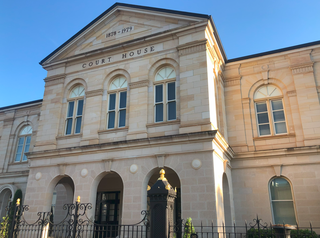
Emerging from Neil Street bus station on a gorgeous Friday afternoon I pass by the heritage-listed old court house. As the sign on this classical building states this was Toowoomba’s court house between 1878 and 1979. Toowoomba was surveyed in 1852 as a replacement for the settlement of Drayton as it was closer to the edge of the range. Toowoomba is thought to be named either after a property in the area in the 1850s, or from an Aboriginal word meaning “place where water sits” or “place of melon” or “place where reeds grow” or “berries place” or “white man”. Whichever it was, Toowoomba became the main town on the Darling Downs when Queensland became a colony in 1859. A small court opened in Margaret St in 1863 but wealthy Downs citizens commissioned this imposing replacement of locally-quarried stone in 1876 designed by prolific Scottish-born government architect Francis Drummond Greville Stanley, who was also responsible for Brisbane’s GPO, Roma St station and some of Charters Towers’ grand buildings. When Toowoomba’s court moved to a new building in 1979, it was used as government buildings before being sold privately in 2000.
Nearby is Toowoomba’s former post office. The post office was also designed by Stanley in classical revival style and complements the Court House in form and material. The post office opened in 1880 as a major staging point on the intercolonial telegraph and operated for 120 years before Australia Post moved to a new building in 1999. It functions now as a cafe and offices.

The third major heritage-listed building in the Margaret-Neil St precinct is Toowoomba’s police headquarters. This Raymond Nowland designed-building is of later vintage than the other two, dating to 1935, replacing an earlier timber structure. There are four parts to the complex: a police station, garage, watch house and keeper’s residence. The Heritage Register says the impressive form is indicative of Toowoomba’s importance as “Queensland’s second city in the urban hierarchy of the state.”

I decided on a long walk from the city to Picnic Point. I passed Queens Park where I would be doing the parkrun in the morning. The 25-hectare park was gazetted as a public reserve in 1869.

I then took the long walkway besides East Creek. There are a number of parks along the creek, all with unimaginative numerical names. Below is East Creek Park 2 between Margaret and Herries St, a pretty and popular lunch destination for city workers with barbecue and picnic facilities. The park is the start of the East Creek cycle route to Spring St, Middle Ridge.

A feature of Park 2 is the Mothers Memorial Garden. The Mothers` Memorial (rear of image below) was the site of military recruitment during the First World War and where Toowoomba’s Anzac Day commemoration has been held since 1916. After the war bereaved mothers sold flowers to raise funds for a Mothers’ Memorial which was originally at the corner of Margaret and Ruthven St in 1922. Calls to move it away from its busy location began in the 1960s and after much controversy it was moved to its present peaceful location in 1985. The trachyte stone memorial is unique in Queensland.

I followed the East Creek path to Long St then diverted up the hill to Picnic Point. These lovely parklands are at the top of the range looking east towards the Lockyer Valley. It is the home of many native birds including the red-browed finch, striated pardalote and pale-headed rosella.

Carnival Falls is an artificial waterfall below the Bill Gould lookout (where the first photo in this blogpost was taken). A bluestone quarry was established here in 1890 to provide stone for roads and buildings including the post office and court house. The quarry closed by the 1940s. The Carnival of Flowers Association built the falls in 1965 in the disused quarry as a planned beautification to attract more carnival visitors. Nearby a Camera Obscura was erected in 1967 with two six-inch lenses offering views of the city and the valley below. It was closed in 1990 and demolished three years later.

Along the path are markers for a scaled model of the solar system. I first spotted Neptune (4.4 billion kms from the sun) and gradually passed most of the remaining inner planets in the next few kilometres. The only sign I missed was the one for Uranus. Perhaps the model had taken Neptune’s elliptical orbit into consideration and Uranus was hidden somewhere beyond it. The marker for Mars (213 million kms from the sun) was just around the corner from Earth, Venus, Mercury and the sun.

Below is the view from the Tobruk Memorial Drive Lookout. On the right is Sugar Loaf and left centre is Table Top Mountain. Over millions of years Table Top eroded leaving only the flat-topped basalt plug and scree slopes. Local tribes knew the mountain as Meewah and in 1840 a white land overseer shot dead Aboriginal men dancing on the mountain peak. The incident unleashed attacks between white and black. By 1843 an alliance of south-east Queensland tribes tried to starve white colonists out. Multuggerah led 100 warriors to ambush a convoy of drays up the Range from Grantham. Angry settlers followed them to Table Top but wandered into a trap of hurled boulders and stones in what became known as the Battle of One Tree Hill. Clashes persisted until 1850 when superior weaponry and the introduction of native police turned the tide.

Walking back to town, I diverted again to Queen’s Park’s Botanic Gardens. Every September the gardens are a centrepiece of internationally renowned Toowoomba Carnival of Flowers. Each year, thousands of seedlings are planted in attractive geometric-shaped garden beds to ensure their blooms peak in time for the Carnival.

A short walk from the Botanic Gardens is “Whyembah” on Campbell St, Toowoomba’s “Grand Lady”. Built around 1896 for commercial traveller John Rosser, the weatherboard house is heritage-listed because it “demonstrates the principal characteristics of an 1890s ornate timber house in Toowoomba”. Rosser was a first class cricketer for Victoria in the 1880s. He also enjoyed lawn bowls and installed a bowling green on the property, though this is now long gone. Rosser died in 1925 and his widow Margaret continued to live there until her death in the 1940s.

As the evening closed in, I passed more heritage-listed buildings. The Strand Theatre on Margaret St was built as a cinema in 1915. Toowoomba councillor James Newman commissioned Brisbane architect George Addison to build it on the site of picture gardens. The American-derived design with its large semi-circular glazed arch was similar to cinemas from the same era in Brisbane and Melbourne though the top level was designed as additional accommodation for Newman’s next door Crown Hotel. Pioneering movie exhibitor Mary Stuart “Señora” Spencer (billed as “The Only Lady Cinematograph Artist in the World”) leased the theatre and named it the Strand like her theatres in Brisbane and Newcastle. The April 5, 1916 Darling Downs said “SEÑORA SPENCER seeing no reason to doubt that the high class features, style, and novelty, that characterise the enormously successful Cinematograph Exhibitions conducted by her at the Strand Theatre, Brisbane, would prove immensely popular with the Toowoomba public.” Though Spencer sold up in 1918, the Strand flourished through the golden age of cinema and still shows movies. Its heritage listing hails its demonstration of “the emergence of cinema as a 20th-century social phenomenon.”

On Neil St is the art deco Empire Theatre. Like the Strand, the Empire was built as a cinema by Brisbane entertainment promoter EJ Carroll in 1911. Although destroyed by fire, substantial sections were included in the 1933 rebuild. Brisbane’s TR Hall & LB Phillips was architect for the new building which accommodated 2500 people, the second largest venue in Queensland. The cinema declined with the advent of television and the local council bought it in 1997 and restored it as a performing arts venue. Its heritage listing calls it “rare and important evidence of the increasingly sophisticated expectations of interwar cinema audiences”.

St Luke’s Anglican Church on Herries St is another heritage-listed building. A primitive church was established on the site in 1857 as Toowoomba began to replace Drayton as the leading town on the Downs. The foundation stone for the current bluestone structure was laid in 1895 and the church opened two years later. St Luke’s was designed in traditional Gothic revival style though it took several phases to complete. A stained glass window is a replica of one at Chartres Cathedral and the church retains a magnificent Norman and Beard pipe organ from 1907. The heritage listing hails St Luke’s as a major work of 19th century English-born ecclesiastical architect John Hingeston Buckeridge, who built 60 churches in Queensland.

The first elected Toowoomba Council in 1861 petitioned the new colony of Queensland for a land grant to build a town hall, originally on the corner of James and Neil Sts. The city expanded greatly that decade with the arrival of the railway from Brisbane and the founding of the Chronicle newspaper. In 1898 the School of Arts on Ruthven St burned down and Council hired English architect Willoughby Powell to design a new city hall on the site in 1900. The new building also incorporated a school of arts, a technical college and a theatre. It opened late that year with the clock added in 1901, which remains a focal point of Ruthven St. The building was heritage listed in the 1990s as its “generous size and grand character provide evidence of the prosperity and importance of Toowoomba as a major regional centre at the turn of the century.”

The White Horse Hotel on Ruthven St is also heritage-listed. The July 7, 1866 Chronicle reported that the hotel “lately opened by worthy Boniface Daniel Donovan” was “capacious” with 19 rooms and built of brick on stone foundations. The hotel changed hands a number of times and in 1912 new owners decided on an ornately detailed rebuild including a new facade and remodelled wings. The pub closed in 1986 and the ground floor is now shops. Its heritage listing promotes its importance as an early 20th century hotel, “in particular the flamboyant facade and interior elements such as the main stair, pressed metal ceilings, doorways, and fanlight.”

I was up early on Saturday morning for my run. I wandered across to Queen’s Park, just 10 minutes away, accompanied only by occasional pedestrians and four-legged friends.

There were a lot more people at the Margaret St end where the parkrun begins. Toowoomba is one of the biggest parkruns in the world and there were over 800 participants the prior week. For reasons unknown, there were a “mere” 550 runners this week but it still made for a crowded start line.

The course is two laps around the park, including the scenic Botanic Gardens. My efforts in my 217th parkrun and 93rd course were captured in this grimacing photo as I cross the finish line in a time of 24:30. Having freshened up and then enjoyed breakfast, I went to the station to get the bus down the range to Brisbane. But I’ll be back. T-Bar has plenty to offer – not least two other parkrun courses to conquer.


One thought on “Toowoomba days”